Description
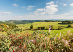
Once you've left Sankt Vith, 90 percent of the route will take you through the High Fens-Eifel Nature Park. That means quiet roads and a lot of woodland along the way. The beautiful Our valley by the border to the German Eifel-Ardennes region is the icing on the cake.
The first 10 km of the route is a continuous uphill climb to reach the elevated village of Meyerode. You then make your way into the valley of the Our, with which you become acquainted in Schönberg. After an idyllic section of 5 km above the Our, the river shows itself off to its best advantage before reaching the village of Setz. You can let your eyes wander across the sprawling valley before you. The flat course of the path here in the valley enables you to gaze into the distance beyond the edges of the path.
In Steinebrück, the 80-metre-high motorway viaduct of the E42 Verviers-Prüm spans the Our valley. The imposing structure makes the valley appear even bigger. Then you continue along the Vennbahn cycle path to Sankt Vith. You pass the (former) railway of Lommersweiler and ride through a tunnel. The former railway line (Vennbahn) was constructed in the valley of the Braunlauf. The cycle path, however, runs along a normal road from Neidingen. In Wiesenbach you return to the original railway track where you can enjoy a safe and quiet ride to the town of Sankt Vith.
Recommended visit: Wiesenbach: The Chapel of St. Bartholomew, a former hermitage dating from 1800. Here, you stroll through ancient lime trees, weathered grave crosses and an overgrown enclosing wall.
Follow the cycle route nodes 84 > 50 > 38 > 40 > 37 > 13 > 41 > 42 > 43 > 83 > 55 > 54 > 46 > 47 > 84
Advice
Wiesenbach: The Chapel of St. Bartholomew, a former hermitage dating from 1800. Here, you stroll through ancient lime trees, weathered grave crosses and an overgrown enclosing wall.
Details
-
Difficulty Medium
-
Physical condition
-
Experience
-
Landscape
-
Highest point
586 m
-
Lowest point
372 m
-
Best period for this activity
January
-
February
-
March
-
April
-
May
-
June
-
July
-
August
-
September
-
October
-
November
-
December
Safety instructions
Watch out for traffic when leaving Sankt Vith. Steep descent with a gradient of 18% between node 42 and node 44.
Recommended equipment
- Helmet
- Sportswear
- Good Footwear
- Roadworthy bike
- Drinking bottle
- Sunglasses
- Rain protection
Information and additional links
East Belgium Tourist Agency npo
Hauptstraße 54
4780 Sankt Vith
+32 80 22 76 64
info@ostbelgien.eu
www.ostbelgien.eu
BE 0715 454 578 - RJP/RPM Eupen
Contact details
Departure
Sankt Vith, at the “Triangel” Cultural Centre, Vennbahnstrasse 2. With your back facing the entrance of the Triangel, take the cycle path to your right towards node 32.
Arrival
Sankt Vith, at the “Triangel” Cultural Centre, Vennbahnstrasse 2
Itinerary
Follow the cycle route nodes 84 > 50 > 38 > 40 > 37 > 13 > 41 > 42 > 43 > 83 > 55 > 54 > 46 > 47 > 84
Difficulty level
-
Difficulty Medium
-
Distance
36.6 km
- Duration
2.50 h.
- Positive altitude difference
401 m
- Positive altitude difference
401 m
Circular walks
Viewpoint(s)
Catering points
Cultural/historical interest
Interest - The flora
Difficulty level
- CountryBelgium
- RegionRégion Wallonne
- ProvinceVerviers
- DepartmentBurg-Reuland