Description
Half the tour leads through the High Fens, where forest areas alternate with expansive peat bogs. The other 20 km takes you past open pastures around the Warche and Robertville reservoir, which you cross twice.
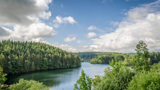
The Botrange Nature Park Centre is the beating heart of the High Fens-Eifel Nature Park situated on Belgian territory. Starting from the visitors’ centre, you cycle through dense forests into the Bayehon valley, which has carved its way deeply into the landscape. You then ride through the open countryside around Robertville. A reservoir was built here on the Warche in the 1920s to provide Malmedy with drinking water. The dam wall is 55 m high and retains almost 8 million m³ of water. The reservoir has meanwhile developed into a tourist attraction and an Eldorado for water sports enthusiasts.
Cows and pastures alternate with quaint and charming hamlets, and you reach the disused railway line when you have crossed the lake for the second time. You follow the Vennbahn cycle path for ten kilometres from the source region of the Rur to Kalterherberg (D). When you reach Sourbrodt, the Vennbahn leads you in solitary fashion through pastureland as far as the eye can see, then alongside areas of the Fens and finally parallel to the burbling Rur. Between Sourbrodt and Leykaul, on the tracks next to the cycle path, you will encounter draisines or railbikes travelling to and fro over a 7-km route.
Adcvice: An 800-metre walk at Robertville reservoir leads to the castle dating from 1354. It rises up above the Warche valley in an imposing manner.
Follow the cycle route nodes: 50 > 76 > 77 > 78 > 55 > 89 > 81 > 45 > 44 > 43 > 42 > 38 > 72 > 71 > 86 > 83 > 80 > 51 > 52 > 50
Advice
An 800-metre walk at Robertville reservoir leads to the castle dating from 1354. It rises up above the Warche valley in an imposing manner.
Details
-
Difficulty Medium
-
Physical condition
-
Experience
-
Landscape
-
Highest point
693 m
-
Lowest point
486 m
-
Best period for this activity
January
-
February
-
March
-
April
-
May
-
June
-
July
-
August
-
September
-
October
-
November
-
December
Safety instructions
Between node 80 and node 51 you will find yourself on a forest trail, part of which does not offer ideal cycling conditions. Please show consideration for hikers between nodes 51 and 50.
Recommended equipment
- Helmet
- Sportswear
- Sturdy shoes
- Roadworthy bike
- Drinking bottle
- Sunglasses
- Rain protection
Information and additional links
East Belgium Tourist Agency npo
Hauptstraße 54
4780 Sankt Vith
+32 80 22 76 64
info@ostbelgien.eu
www.ostbelgien.eu
BE 0715 454 578 - RJP/RPM Eupen
Contact details
Departure
Botrange, Naure parc centre, route de Botrange 313
Arrival
Botrange, Naure parc centre, route de Botrange 313
Itinerary
Follow the cycle route nodes: 50 > 76 > 77 > 78 > 55 > 89 > 81 > 45 > 44 > 43 > 42 > 38 > 72 > 71 > 86 > 83 > 80 > 51 > 52 > 50
Difficulty level
-
Difficulty Medium
-
Distance
40 km
- Duration
2.57 h.
- Positive altitude difference
481 m
- Positive altitude difference
481 m
Circular walks
Viewpoint(s)
Catering points
Interest - The flora
Difficulty level
- CountryBelgium
- RegionRégion Wallonne
- ProvinceVerviers
- DepartmentBütgenbach